


Enhancing urban management capabilities and service levels to promote sustainable urban growth
The MapGIS smart city spatio-temporal big data platform collects urban spatio-temporal information such as basic geographic information data, public thematic data, real-time perception data of the Internet of Things, Internet data and local extended characteristic thematic data through big data, the Internet of Things, cloud computing and other information technologies, to achieve the convergence, governance and integrated management of spatio-temporal data resources, provide unified services for all kinds of smart applications, and build a smart city application base.
MOREThe integrated platform of intelligence, intelligence, and action focuses on business scenarios such as efficient handling of normal police situations, integrated combat of major cases and events, command and dispatch of special tasks, and intelligent investigation and control of key personnel and vehicles. Starting from practical application needs, it constructs an intelligent platform that is "predictive and early warning, lightweight and flexible, quick response, precise strike, joint logistics and defense, full domain adaptation, and multi functional and efficient", and builds a three-dimensional social security prevention and control pattern that is "full of fields, full of elements, full of goals, full of time and space, and full coverage".
The police geographic information platform is an important foundational and comprehensive application support platform for public security informatization, with unique advantages in visualizing and integrating business information and spatial decision analysis. Our company's public security spatiotemporal information platform benchmarks the PGIS2.0 project and PGIS standard specifications, builds a public security spatiotemporal information cloud platform, establishes a public security spatiotemporal big data governance system, continuously explores the application value of public security spatiotemporal big data, expands artificial intelligence applications, and promotes the improvement from perception to cognition.
Zhongdi Digital relies on leading GIS technology and over 20 years of experience in the drainage industry to provide a full process management solution for households, stations, factories, and rivers.
With the GIS platform as the core, based on the scientific, standardized and standardized modern gas management concept, make full use of mobile Internet, Internet of Things, big data, cloud computing, artificial intelligence, BIM, GIS, AR/VR/MR and other advanced technologies to help enterprises consolidate the pipeline data base, sort out business processes, improve performance assessment, optimize operation management, and promote gas enterprises from digital to intelligent.
Build an application system for smart water management from data collection to value enhancement to business process reengineering, ultimately achieving a smart application loop of visualized water supply asset management, business dataization, data assetization, and scientific decision-making.
The platform relies on the urban government big data center and various departmental resources to integrate, correlate, mine, and analyze massive data, promote business collaboration through data centralization, achieve real-time monitoring of social governance status, intelligent early warning of social anomalies, intelligent decision-making of key issues, collaborative disposal of major events, dynamic supervision and assessment of governance work, create a closed loop of social governance operation and management, and achieve modernization of the urban governance system and improvement of governance capabilities.
Based on the MapGIS spatiotemporal big data platform technology framework, using spatiotemporal as the foundation, we integrate rural basic geographic data, agricultural industry data, rural environmental governance data, and rural government service information to build an agricultural and rural big data center, carry out digital rural informatization construction, and promote the development of beautiful countryside.
The MapGIS smart park solution integrates GIS, BIM, IoT, big data AI、 Cloud computing, 5G, mobile internet and other technologies, relying on intelligent infrastructure, have built a three-dimensional digital base for the real scene of the park, realizing basic capabilities such as rapid collection, high-speed transmission, centralized computing, and intelligent processing of information resources. The solution integrates various subsystems of the park, realizing the transition from single scene intelligence to overall intelligence of the park, making "intelligence" penetrate every detail of park management and operation, improving industrial agglomeration ability, and empowering enterprise management innovation.
Promote the construction of ecological civilization and provide basic support for the construction of "Digital China"
Closely focusing on the requirements of smart city and digital government construction, implementing the deployment of information and innovation work, creating a comprehensive intelligent national land spatial basic information platform for information and innovation, and consolidating the platform's basic support capabilities;
MORE


Provide information services based on geological resource related data to achieve deep mining, sharing, and exchange of geological resource information.
-
MapGIS Digital Twin Watershed Solution
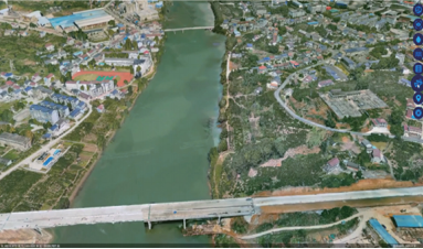
Zhongdi Digital closely adheres to the relevant requirements of the Ministry of Water Resources on smart water conservancy construction, and uses the independently controllable national production MapGIS platform as the GIS application support for the smart water conservancy digital twin platform to create the MapGIS digital twin watershed solution, which solves the problems of integrated management of all element information in the watershed, digital simulation of business, and expression of application scenarios, providing assistance for the construction of "2+N" water conservancy business application scenarios.
MORE >
-

MapGIS Groundwater Informatization Solution
The underground water information solution is supported by the MapGIS platform, which integrates the storage and management of monitoring data, hydrogeology, related business management and other types of data, explores the deep value of data, supports the output of 2D and 3D thematic results, vividly displays the occurrence state of underground water under natural geological conditions, creates multiple underground water thematic information application scenarios, and provides data support for underground water development and utilization, underground water ecological protection, engineering construction impact assessment, etc.
MORE >
-
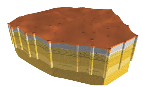
MapGIS Iterative Geological Modeling Tool
Compared with traditional two-dimensional geological data representation methods, three-dimensional models can fully and accurately express the boundary conditions of complex geological phenomena and various geological structures contained within geological bodies, intuitively reproduce the spatial distribution and interrelationships of geological units, and maximize the intuitiveness and accuracy of geological analysis. Therefore, 3D geological modeling technology has a wide range of application fields, including regional geological surveys, mineral resource exploration, mine design, mine production management, urban geological surveys and urban underground space management, hydrogeology, engineering geology, environmental geology, earthquake prediction, and many other industries that play a supporting role in the national economy.
MORE >
-

Geological Informationization Solution
To carry out information technology applications that integrate data collection, processing, standardization, auxiliary mapping, 3D modeling, analysis and evaluation, and information sharing in various fields such as urban geology, mineral resources, underground space, engineering exploration, geological environment, coastal zone, and seismic geology
MORE >
-

MapGIS Geological Data Management and Display System
The MapGIS Geological Data Management and Display System has developed a standardized management model for geological data based on the "Guidelines for the Construction of Geological Environment Survey Databases for Important Economic Zones and Urban Agglomerations (2014 Edition)" and the "Structural Specification for Urban Geological Survey Databases (DD2015-04)". The aim is to free geological professionals from the tedious work of data collection and organization, improve work efficiency, and promote the application and service of geological information.
MORE >
-

MapGIS Field Data Collection System
The MapGIS field data collection system starts from the actual needs of field investigations, based on the investigation business itself, and applies GIS technology, modern database technology, visualization technology, and computer network technology to build a field data collection backend management system and a field data collection system mobile end, realizing real-time storage and sharing of investigation data, providing information support for field investigations, and improving the quality and efficiency of field data investigation work; At the same time, it directly collects and stores field survey data, and can be connected with professional mapping tools to assist in the full process informatization transformation from "investigation database construction mapping modeling".
MORE >
MapGIS Digital Twin Watershed Solution
MapGIS Groundwater Informatization Solution
MapGIS Iterative Geological Modeling Tool
Geological Informationization Solution
MapGIS Geological Data Management and Display System
MapGIS Field Data Collection System
Provide high-quality solutions and services for more industry users and partners
-

 Series solutions for the communication industryA new generation of communication network resource sharing service platform developed based on MapGIS platform, which efficiently combines GIS technology, database technology, computer network, and communication network management automation to achieve refined, visualized, intelligent, and full lifecycle management services for communication network resources.MORE
 -

 MapGIS CIM Underground Space PlatformThe product takes "GIS+BIM+IoT" as the starting point to build an open and scalable MapGIS CIM underground space platform product, realizing the integrated management, visual rendering, and processing analysis of all elements of underground space information. It provides a comprehensive product for integrated resource management and sharing, visual display and professional analysis, rapid application construction, and global linkage for the informationization construction of underground space. The platform is built using the "1+1+N" model to create a unified digital base for underground spaces, and to build specialized applications at different business levels to provide services for the construction of underground spaces.MORE
 -

 Smart wind power solutionOrganically integrate high-tech means such as cloud computing, big data, the Internet of Things, virtual reality, and artificial intelligence with the planning, design, construction, safety supervision, operation and maintenance processes of wind power enterprises, and build a smart wind power control platform that covers the entire level, business, and process of the enterprise.MORE
 -

 Solution for Radio and Television Resource ManagementThe Radio and Television Network Resource Sharing Service Platform is a comprehensive platform for radio and television network resource management developed based on GIS technology. On the basis of spatially maintaining and displaying communication network resource data, it supports the configuration and maintenance of customer business line information, provides grid refinement management tools, and provides strong support for daily work such as planning and design, external construction, line configuration, emergency repair, equipment line inspection, etc., effectively solving the difficulties of resource line maintenance and complex management. At the same time, through in-depth mining and analysis of resource data, information support is provided for front-end business and marketing analysis, and core data support is provided for enterprise information operation.MORE
 -

 Transportation Meteorological Support Service SolutionThe transportation meteorological service platform is based on GIS and integrates monitoring, forecasting, and early warning information release, achieving the release of specialized, refined, and quantitative transportation meteorological service products.MORE
 -

 High performance processing solution for remote sensing imagesThe high-performance processing solution for remote sensing images adopts new software and hardware technologies based on multi-core processors, high-speed networks, high-speed storage, efficient file systems, scheduling systems, and workflow management systems.MORE
 -

 Multi source remote sensing data management solutionThe multi-source remote sensing data management solution adopts a service-oriented design concept and a multi-layer architecture, realizing data organization for spatial entities and their relationships, efficient storage and indexing of massive spatial data, and large-scale multi-dimensional dynamic spatial information database.MORE
 -

 Solution for Multi source Meteorological Information Integration Application and Service PlatformThe integrated application and service platform for multi-source meteorological information establishes an integrated application database based on forecast products, analysis products, detection data (including radar, satellite cloud images, automatic stations, wind profiles, microwave radiometers, etc.), weather case libraries, and data mining results.MORE


