Connect to DeepSeek! MapGIS enriches the application of large-scale model geographic intelligent Q&A
Recently, the DeepSeek large model has pushed the AI wave to new heights, with various new AI scenarios and applications emerging constantly. In the field of geographic information, DeepSeek has also brought new vitality to the development of intelligent agent applications for GIS software. Recently, the domestic GIS software MapGIS integrated the DeepSeek large model, further enriching its large model geographic intelligent Q&A application process.
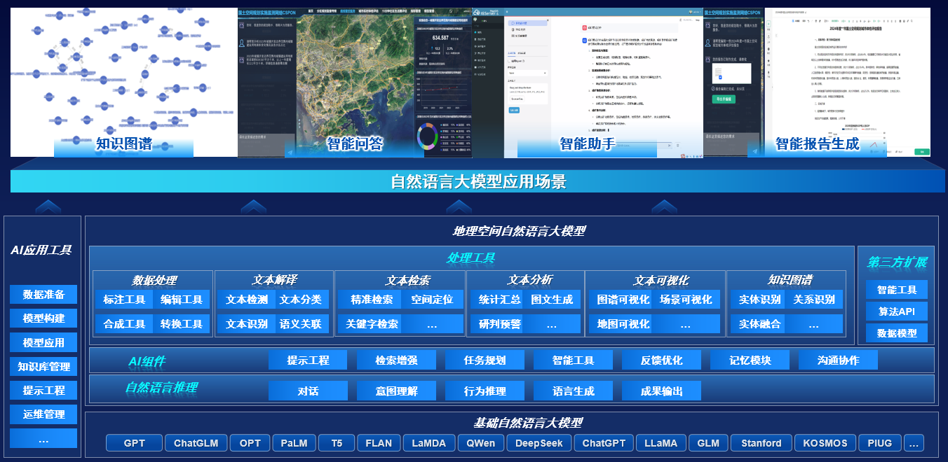
Based on natural language large models, MapGIS has conducted research on geographic spatial natural language large models, supporting natural language reasoning, providing AI components, and developing processing tools for data processing, text interpretation, text retrieval, text analysis, text visualization, and knowledge graphs, as well as AI application tools. Based on this, the MapGIS large model geographic intelligent Q&A application process integrates commonly used models such as ChatGLM, DeepSeek, and Qwen, realizing scenarios such as geographic knowledge base intelligent Q&A applications, geographic intelligent agent applications, and geographic knowledge graph applications, and has launched tools such as natural resources intelligent business assistants, intelligent report generation, and planning scheme preparation for industries such as natural resources and geology.

MapGIS Geographic Spatial Natural Language Large Model
I. Technology Leadership: Two Intelligent Q&A Modes, Building Industry Intelligent Hub
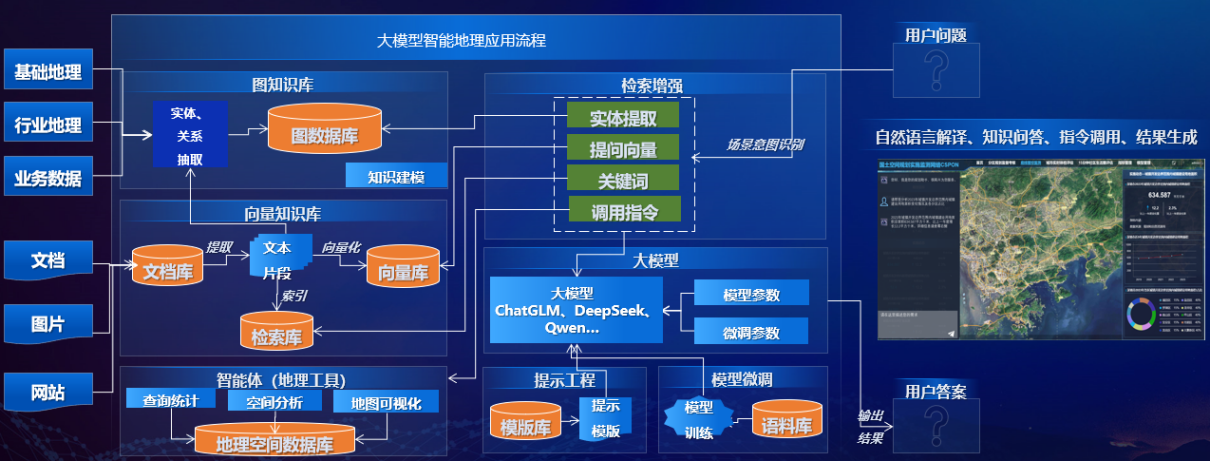
The MapGIS large model geographic intelligent Q&A application process provides two modes: knowledge base Q&A and intelligent agent Q&A. Knowledge base Q&A is divided into graph knowledge base and vector knowledge base based on different data sources. Graph knowledge base construction mainly extracts entity relationships from structured basic geographic data, industry geographic data, and business data, combines with local knowledge modeling to form geographic knowledge graphs, and stores them in graph databases to form graph knowledge bases; vector knowledge bases mainly store unstructured documents, images, web pages, videos, and other data in document libraries, then extract text fragments, and vectorize them to form vector knowledge bases. Both graph knowledge bases and vector knowledge bases can serve as Q&A data sources. The intelligent agent function can also be enabled to parse Q&A parameters, pass parameters to large models, call external geographic tools or API interfaces, and realize advanced functions such as query statistics, visualization display, and spatial analysis of Q&A results. MapGIS configures model fine-tuning technology for large models and continuously optimizes prompt engineering templates and rules. After extensive pre-training, it presets prompt engineering templates for multiple scenarios to improve the efficiency and accuracy of Q&A.

MapGIS Large Model Geographic Intelligent Q&A Application Process
Mode 1: Knowledge Base-Based Intelligent Q&A Mode
MapGIS provides two methods: vector knowledge base (RAG) intelligent Q&A and graph knowledge base (GraphRAG) intelligent Q&A.
● Vector Knowledge Base (RAG) Intelligent Q&A
Vector knowledge base (RAG) intelligent Q&A requires processing the knowledge base and user input information into numerical vectors, and matching based on numerical vectors to achieve efficient and accurate output.
Users can upload massive unstructured data such as local txt, docx, md, pdf, and images to the document database, which is uniformly stored and managed by MapGIS DataStore.
The system loads and parses local documents, converting various unstructured data into structured plain text data. These plain text data may be very long and inconvenient for subsequent matching. Usually, MapGIS segments them into smaller text fragments based on GIS characteristics and industry attributes.
The processed text fragments can be directly stored in the retrieval database as retrieval keywords for subsequent Q&A systems, or after entity and relationship extraction, stored in graph databases to form knowledge graphs and participate in knowledge graph Q&A. They can also be converted into numerical vectors through Embedding technology and stored in vector databases. These vector data can capture semantic information of text and can be directly used for knowledge base Q&A.
For user input questions, the same Embedding technology converts questions into numerical vectors to form query vector information. The query vector information is passed to pre-trained large models such as ChatGLM, DeepSeek, and Qwen for intent recognition and interpretation, and the query vector is compared with all knowledge base text block vectors in vector storage. Based on similarity scores, the most relevant text blocks to the query are selected. Then the user's query and related text blocks are combined into a prompt and sent to the large language model, which returns the final response to the user's query.
Currently, MapGIS has verified multiple business scenarios and provided templates such as natural resources business Q&A assistants and geological report intelligent Q&A.
● Graph Knowledge Base (Graph RAG) Intelligent Q&A
The core of graph knowledge base (GraphRAG) intelligent Q&A is the geographic knowledge graph, which can describe relationships and attributes between geographic entities, thus supporting subsequent intelligent reasoning and Q&A.
MapGIS utilizes the powerful semantic understanding and reasoning capabilities of LLM to extract a large number of entity-relation-entity triples from text, and imports the results into graph databases to create corresponding entities, relationships, and attributes, forming knowledge graphs. In this process, the structured data of knowledge graphs can improve the professional knowledge and output quality of LLM large models, while the capabilities of LLM large models can update and maintain the knowledge graphs themselves.
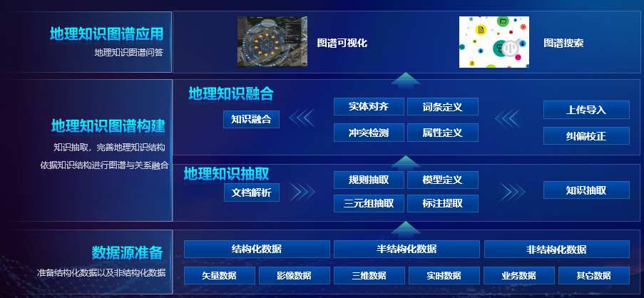
The MapGIS knowledge graph construction process mainly includes data preparation, knowledge graph construction, and knowledge graph application. The system has broad application prospects in multiple fields and can significantly improve the quality and efficiency of geographic information services.

MapGIS Knowledge Graph Construction Process
Data Preparation: Obtain geographic data from multiple data sources, including remote sensing images, social media, IoT sensors, images, documents, and websites as unstructured data, as well as raster data, vector data, and topological data as structured data in geographic spatial databases. Then clean, integrate, and preprocess the data to ensure data quality and consistency.
Knowledge Graph Construction: is the core of knowledge graphs, including traditional knowledge graph construction and large model-based knowledge graph construction.
Traditional knowledge graph construction can be achieved through knowledge graph ETL tools, which can batch process massive data, extract knowledge entities and relationships, integrate graphs and relationships based on knowledge structures, and store results in graph databases as data sources for large model-based knowledge graph retrieval.
Large model-based knowledge graph construction can adopt Q&A methods, utilizing the capabilities of large models such as ChatGLM, DeepSeek, and Qwen to real-time mine entities and relationships in knowledge bases, and store the extracted knowledge graph data in graph databases to expand knowledge graph data sources. The graph data mined by large models can also be returned to front-end pages in various forms such as JSON format object arrays and lists.
Knowledge Graph Application: Graph retrieval and visualization can be achieved through the geographic knowledge graph Q&A process.
To support knowledge graph vector retrieval, nodes or relationships need to be embedded (as attributes) when creating graphs. Natural language is converted into query languages that graph databases can understand using LLM, and then similar nodes and relationships are retrieved based on vector retrieval as context. Finally, knowledge graph visualization is achieved through front-end components.
MapGIS uses NebulaGraph to store graph data, which can handle graph data with billions of vertices and trillions of edges, providing millisecond-level query speed.
Knowledge graph results have been applied to multiple scenarios such as natural resources real estate registration, geological intelligent mineral exploration, geological disaster evaluation, and geological report intelligent Q&A. For example, in the real estate registration field, front-end knowledge graph visualization widgets can be called to display graph retrieval results in MapGIS full-space single-map products. Based on layered unit 3D model stereoscopic management, knowledge graphs can display association relationships between buildings-units-floors, person-house-land association relationships, house and electronic certificate association relationships, and support knowledge graph query retrieval to achieve efficient and convenient management and application of real estate registration.
Mode 2: Intelligent Agent-Based Q&A Mode
MapGIS's Q&A mode based on intelligent agents leverages the Agent capabilities of LLM to achieve multi-step reasoning for geographic problems, and calls tools and API interfaces. Through prompt fine-tuning methods, it improves LLM performance and enhances LLM's performance in GIS intelligent Q&A scenarios.
To guide the model to correctly call APIs, MapGIS also writes specific prompts for processing tools and formulates configuration rule files to enhance API functionality. Through this tool, service interfaces provided by MapGIS DataStore, MapGIS IGServer, and other products can be called to achieve big data storage services, high-performance GIS services, and other functions, realizing big data storage and management, query statistics, map display, visual expression, spatial analysis, and other common functions. Combined with Web front-end components, interactive pages are provided to support visual output of results.
To ensure generation accuracy, MapGIS repeatedly adjusts prompt structure and combinations, continuously optimizing prompt engineering templates, and forms multiple intelligent agent application scenario templates to guide users in training models that better meet GIS industry needs.
Innovating the intelligent Q&A mode of intelligent agents, MapGIS has applied the results to natural resources intelligent interaction scenarios. Users input questions according to prompt engineering templates, natural language large models interpret user intent, parse parameters in questions, and then intelligent agents pass parameters to MapGIS tools, execute tools and generate results. Intelligent agents then call service interfaces to return results to Web front-end visualization components, and achieve visual display of results through front-end components.
The intelligent interaction function module also supports complex workflow calls, such as report generation processes. The system first interprets user intent through natural language large models, retrieves knowledge bases based on report generation templates, and finally generates content for each chapter of documents step by step. For example, the indicator calculation tools provided by the "Single Map" Implementation Supervision Information System for Territorial Spatial Planning generate urban health check report documents involving calculations of over 100 indicators, analysis and summary of calculation results for each indicator, and save them as word documents in combined forms of charts, text, and maps, achieving automatic report writing.
II. Product-Based: Four Innovative Products Fully Supporting Application Implementation
MapGIS constructs a solid technical foundation for intelligent Q&A applications with four core products, providing full-stack capability support for industry users from data management to intelligent analysis.
MapGIS DataStore (Distributed Storage Engine): The product's powerful data storage capabilities can be used to store user-uploaded structured and unstructured data, as well as vector data generated from text conversion and graph data generated from knowledge graph construction. It can also provide big data storage services such as vector big data storage, image big data storage, text big data storage, real-time big data storage, vector big data storage, and knowledge graphs based on services provided by the product, supporting intelligent agents to achieve big data query statistics, big data analysis, knowledge graph construction, and other intelligent agent applications.
MapGIS IGServer (High-Performance GIS Analysis Server): Mainly provides REST service interfaces such as map services, feature services, scene services, image services, geometric analysis services, and geographic processing services for intelligent agent applications, supporting intelligent agent applications to achieve map visualization, querying, and spatial analysis functions.
MapGIS IGServer-S (Intelligent GIS Analysis Server): Based on deep learning frameworks, it provides intelligent services such as data association and fusion, spatial analysis and prediction, clustering classification and statistics, information extraction, intelligent modeling, intelligent analysis, and intelligent interaction, covering intelligent GIS functions such as data management, model construction, model analysis, and application construction.
Data Management: Mainly used to manage intelligent Q&A datasets and Agent datasets, providing functions such as input, editing, and deletion of questions and answers, as well as input, editing, and deletion of Agent intelligent agents, interfaces, and interpretation results. It also provides various workflows such as slicing, cleaning, filtering, deduplication, and privacy removal to improve sample data quality and optimize model performance.
Model Construction: Supports building traditional models and large models, supporting model development, model pre-training, model fine-tuning, model evaluation, and other functions to ensure the accuracy of intelligent Q&A results.
Model Analysis: Mainly provides model inference and intelligent analysis functions, providing real-time and offline inference services, batch prediction tasks, and other functions.
Application Construction: Provides tools for interactive low-code development of intelligent applications, supporting the rapid construction of AI applications such as intelligent agents and intelligent assistants. It has built-in various prompt engineering templates, supports external plugin registration and management, provides configuration management of large model preprocessing and post-processing rules, and visual process building.
MapGIS Pan-Spatial Map (Full-Space Single Map Product): Mainly provides various front-end widgets such as knowledge graph visualization, query statistics, and visual expression widgets to support front-end expression of intelligent agent applications, making intelligent analysis results "clear at a glance."
Making geographic information more intelligent, improving efficiency, and making decisions more precise, MapGIS is accelerating the industry's move towards the "GIS+AI" new era with technological power. In the future, MapGIS will continue to innovate intelligent GIS technology, upgrade IGServer-S platform capabilities, deepen the integration of large models and geographic information, expand more intelligent application scenarios, and provide intelligent and efficient geographic information services for more industries.


