


Smart Geology
Provide information services based on geological resource related data to achieve deep mining, sharing, and exchange of geological resource information.
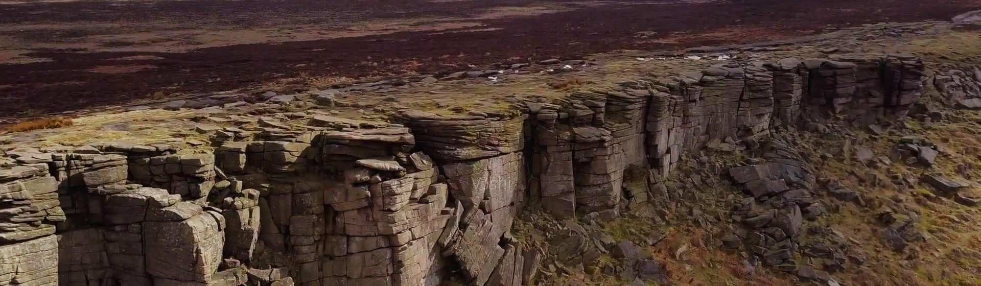
Compared with traditional two-dimensional geological data representation methods, three-dimensional models can fully and accurately express the boundary conditions of complex geological phenomena and various geological structures contained within geological bodies, intuitively reproduce the spatial distribution and interrelationships of geological units, and maximize the intuitiveness and accuracy of geological analysis. Therefore, 3D geological modeling technology has a wide range of application fields, including regional geological surveys, mineral resource exploration, mine design, mine production management, urban geological surveys and urban underground space management, hydrogeology, engineering geology, environmental geology, earthquake prediction, and many other industries that play a supporting role in the national economy.
MapGIS Iterative Geological Modeling Tool is a professional software tool specifically designed for 3D geological modeling work, providing full-process services. It integrates data import, data processing, data checking, model construction, efficient visualization, 3D analysis, result output, and user collaboration, achieving efficient expression of complex geological body morphology and geological structures, providing strong support for digitalization and visualization of geological models.

ProductFunctions
·Multi-source Data Import, Visualization and Editing
To meet geological professional needs, MapGIS Iterative Geological Modeling Tool supports importing various geological professional data for modeling, including borehole data, cross-section data, geological maps, surface DEM, and geophysical and geochemical exploration data.
·Automatic Structural Model Construction
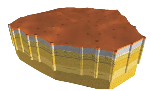
Supports users to use any data such as geological maps, topographic data, borehole data, cross-section data, and geophysical data to construct geological body models layer by layer from the surface underground. Each stratum layer selects different modeling methods based on expert experience to construct stratum models. Multi-layer stratum models constitute geological models, while supporting the expression of geological structures such as lens bodies, pinch-outs, and repeated inversions.

Automatic Construction of Geological Models Including Lens Bodies
·Interactive Structural Model Construction
Adopting the "divide and conquer" concept, each unit in geological body modeling uses human-computer interactive modeling methods, fully integrating geological experts' knowledge into the modeling process, and finally completing the merger of all units' geological models to fully express various complex geological structures such as folds, faults, and caves.
·Grid Discretization Attribute Modeling
Grid discretization attribute modeling is used for regularized 3D spatial distribution modeling of physical, chemical attribute values and other geological parameters within geological bodies, such as porosity, water storage rate, permeability coefficient, and geochemical element contents such as Au, Ag, and Cu. Based on 3D geological structure models, it supports rapid discretization and efficient rendering of billion-level multi-precision grids. Combined with MapGIS's precise and efficient parallel interpolation methods, it achieves rapid attribute model construction. Providing MapGIS's precise and efficient parallel interpolation methods, it supports 3D spatial attribute research in fields such as geophysics, geochemistry, and geological environment.

·Model Analysis
MapGIS Iterative Geological Modeling Tool provides rich 3D model display, query, and analysis functions, including moving, rotating, zooming in, zooming out, attribute parameter query and modification, as well as explosion, cutting, roaming and other analysis functions in different ways. The combination of multiple methods meets display and analysis needs under different situations.
Product Features
·Iterative Modeling Concept
From framework model to refined model, from whole to part, build level by level with layer-by-layer constraints to restore the most realistic 3D strata; add original modeling data anytime, adjust 3D modeling algorithms anytime, add geological expert experience anytime to achieve the most flexible modeling process.

·Precise Data Tracing
Supports snapshot-style management of models and data. The system automatically records every modeling process, allowing users to trace back to any version of the model, compare model change processes, and evaluate model effects.

Model Version Management
·Multi-type Modeling Algorithms
Provides multiple modeling algorithms to match different modeling needs. Includes data precision adaptive grading algorithms, automatic data fitting constraint algorithms, automatic 3D topological tracking algorithms, interpolation algorithms (inverse distance power method, trend surface interpolation method, spline function interpolation method, Kriging method, etc.), forming modeling technologies such as automatic borehole modeling, automatic zoning map modeling, implicit modeling, automatic cross-section modeling, interactive cross-section modeling, and automatic attitude extrapolation modeling, applicable to multi-topic 3D modeling scenarios such as bedrock geology, engineering geology, and hydrogeology.
·Easy to Use
Clear software function logic, smooth interaction, low learning cost, short learning curve, and even without experience, users can quickly get started and easily construct 3D geological models.
Application Cases

Related Software
Smart City
- Smart City Spatiotemporal Big Data Platform
- MapGIS Smart Thermal Solution
- Smart Emergency Command Platform
- MapGIS Field Work Order Solution
- Enterprise One Picture Solution
- Smart Security Combat Platform
- MapGIS Pipeline GIS Solution
- Smart Chemical Industrial Park Solution
- Smart Patrol and Prevention Platform
- MapGIS Integrated Management System Solution for Underground Municipal Facilitie
Natural Resources
- National Land Space Basic Information Platform: Smart Hub
- National Spatial Planning Implementation Monitoring Network (CSPON)
- Real estate convenience service system
- Realistic 3D Solution
- Natural Resource Asset Management Solution
- One code land management solution
- Ocean monitoring solutions
- Intelligent Disaster Management Solution
- Integrated solution for natural resources e-government
- Land survey solution
Smart Geology
- MapGIS Digital Twin Watershed Solution
- MapGIS Groundwater Informatization Solution
- MapGIS Iterative Geological Modeling Tool
- Geological Informationization Solution
- MapGIS Geological Data Management and Display System
- MapGIS Field Data Collection System
- MapGIS Smart Environmental Protection Solution
- Integrated solution for urban geology above ground and underground
- Geological big data cloud platform
- MapGIS Mining Management and Modeling System
More Applications
- Series solutions for the communication industry
- MapGIS CIM Underground Space Platform
- Smart wind power solution
- Solution for Radio and Television Resource Management
- Transportation Meteorological Support Service Solution
- High performance processing solution for remote sensing images
- Multi source remote sensing data management solution
- Solution for Multi source Meteorological Information Integration Application and Service Platform
- Solution for Visualization Platform of Meteorological 3D Storm Body Echo Data
- Solution for Weather Radar Construction Business Platform


