


Smart Hub
Closely focusing on the requirements of smart city and digital government construction, implementing the deployment of information and innovation work, creating a comprehensive intelligent national land spatial basic information platform for information and innovation, and consolidating the platform's basic support capabilities;
Driven by big data and large models, it strengthens real-time perception, intelligent planning, and smart supervision of natural resources and territorial space, building the territorial space basic information platform into the "smart hub" of natural resources and planning informatization. The data acquisition and governance system is more robust, smart capabilities are greatly enhanced, new application scenarios continue to expand, and the technical ecosystem is secure and controllable, supporting the comprehensive transformation and upgrading of smart land and the construction of new smart cities.

Functional Panorama:

Six Core Capabilities:
The new-era territorial space basic information platform (information innovation) closely integrates with domestication, real-scene 3D, and artificial intelligence requirements, possessing six core capabilities: autonomous security and controllability, multi-source data integration, panoramic visual analysis, application collaboration support, proactive monitoring and early warning, and intelligent simulation decision-making. It provides more powerful data service supply and intelligent assistance, achieving traceability of the past, controllability of the present, and simulatability of the future.

1. Autonomous Security and Controllability:

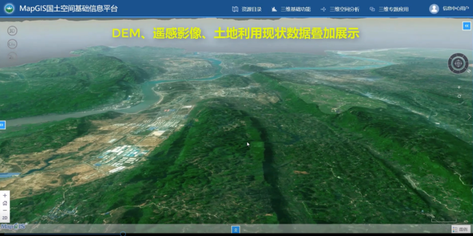
2. Multi-source Data Integration:
For basic geographic data, oblique photography data, 3D model data, underground pipeline data, IoT perception data, and application-specific data, it provides a full-process treatment through data collection and aggregation → data standardization → data modeling → data fusion and processing → service sharing and usage.

3. Panoramic Visual Analysis:

4. Application Collaboration Support:
Based on workflows, forms, and unified authentication, it builds intelligent collaborative support capabilities for business applications, including intelligent recognition, automatic approval, automatic process optimization, natural language processing, and knowledge graphs.

5. Proactive Monitoring and Early Warning:
Supports four early warning methods: indicator early warning, location early warning, usage early warning, and procedure early warning, achieving evaluation, monitoring, and early warning of territorial space.

6. Intelligent Simulation Decision-making:
Facing the smart natural resources stage, through the construction of an indicator library, it filters, refines, and processes useful information from old and new data through data mining and knowledge graphs to form knowledge. Then, through the construction of a model library, scenario simulation, machine learning, and visualization are performed to achieve trend judgment and intelligent decision-making, gradually precipitating a set of general and intelligent tools to serve high-frequency application scenarios.

Application Cases:
Chuxiong Prefecture Territorial Space Basic Information Platform and Territorial Space Planning "One Map" Implementation Supervision System Construction Project
Yuxi City Territorial Space and Planning "One Map" Implementation Supervision Information System Construction Project
Dehong Prefecture Territorial Space and Planning "One Map" Implementation Supervision Information System Construction Project
Guilin LinGui District Territorial Space and Planning "One Map" Implementation Supervision Information System Construction Project
Wufeng Tujia Autonomous County Territorial Space Basic Information Platform and "One Map" Implementation Supervision System Construction Project
Hangjin Banner Territorial Space Basic Information Platform and "One Map" Implementation Supervision Information System Project
Zaoyang City Territorial Space Planning Database and Information Platform Construction Project
Related Software
NRSMA
NRSDMS
- Natural Resource Asset Management Solution
- Intelligent Disaster Management Solution
- Solution for Urban Physical Examination Evaluation Information
- Implementation Supervision Information Solution for the "One Map" of National Spatial Planning
- Solution for Land Space Use Control and Supervision
- Green Mining Intelligent Solution


