


NRSDMS
Based on the demand for intelligent and green transformation of mines, we aim to build an industry application level product that integrates digitalization of mining infrastructure on the enterprise side and intelligent supervision of green mines on the government side, targeting mining enterprises, natural resources, emergency management and other competent departments.
By fully connecting intelligent monitoring equipment, constructing multi-dimensional monitoring indicator early warning models, and building an integrated information platform for government-enterprise interconnection and sharing, the system achieves full-process monitoring and supervision of mine development and protection, production and operation, and closed-loop management of related issues throughout the entire process of "discovery, early warning, verification, disposal, and feedback".
Product Highlights:
Intelligent Supervision System for Green Mines
Fully connecting mine intelligent monitoring equipment, based on web and mobile terminal linkage mode, achieving real-time monitoring, dynamic analysis, and automatic early warning of mine-wide areas. Combined with daily inspections to promote early discovery and early warning of problems, joint multi-department collaborative verification, disposal, and synchronized feedback of results, realizing cross-level, multi-role participation, and closed-loop management throughout the entire process and multiple nodes.
Construction Content:
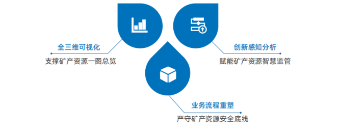
1. One-map Overview
Aggregating and governing existing mineral resource basic data as well as data related to mineral resource planning, mining rights management, exploration/mining/ecological restoration. Meanwhile, gradually advancing 3D visualization modeling of mining areas, integrating mine intelligent monitoring and supervision data, building a smart mine one-map, and achieving integrated 2D/3D display and statistical analysis of mineral resources.

2. One-screen Intelligent Management
Focusing on all-domain mineral resources, facing government institutions, business departments, mining-related legal entities, and public groups, conducting integrated dynamic monitoring, analysis, and display of mine spatial information, mineral resource protection and planning, mining rights management, exploration and mining, mine ecological restoration, and intelligent supervision indicators of mineral resources in the form of maps-text-tables. This provides an intuitive visual and dynamically interactive digital "dashboard" for building a mineral resource governance system with "digital empowerment, intelligent control, and high-efficiency implementation".

3. Comprehensive Early Warning
Connecting with enterprise-end mine digital systems, based on requirements for safe compliant production and ecological environmental protection, constructing professional models such as drill rig criticality, dust concentration exceeding standards, slope angle instability, and license expiration. Conducting problem judgment and graded early warning based on real-time monitoring data.

4. Daily Patrol
Regularly dispatching patrol tasks through the web end and tracking statistics, providing route navigation, online patrol reporting, and problem verification tracking on mobile terminals, achieving information linkage between grassroots patrol verification and management-level early warning disposal.

Mine Basic Digital System
Fully utilizing advanced 3D geological modeling technology and real-time intelligent monitoring equipment, aggregating thematic data such as mine design, mining, transportation, processing, sales, and resource reserves. Achieving full-process monitoring and early warning of mining area production and operation based on 3D visualization, to accelerate the realization of digitalization of mine enterprise production factors, visualization of application scenarios, and intelligent control of management decisions.
Construction Content:
1. Overboundary Mining Early Warning
Establishing electronic fences for mining areas, real-time positioning and monitoring the location information of mining vehicles. Automatically issuing corresponding level warnings when vehicles approach or exceed the fence.

2. All-round Video Surveillance
Dynamically accessing mining area surveillance videos for AI analysis, identifying scenarios such as not wearing safety helmets and smoking in warehouses, automatically issuing early warnings and capturing video clips and photos as evidence.

3. Real-time Dust Monitoring
Real-time access to dust and noise monitoring values, drawing indicator trend charts, timely early warning of over-standard situations, and remote control of spray fog cannons and other devices for dust reduction treatment.

4. Real-time Personnel and Vehicle Positioning
Integrating high-precision positioning, video AI analysis, and fence monitoring to identify behaviors such as fatigued driving, driving while making phone calls, vehicle speeding, and route deviation, and issue early warnings.

5. Underground Safety Supervision
Monitoring and early warning of the on/off status of underground mine ventilation equipment, ventilation wind speed, and harmful gas concentration, combined with underground 3D real-scene models for verification and disposal.

6. Slope Online Monitoring
Through slope monitoring and regular inspections, dynamically monitoring and warning slope displacement, unstable slope control measures, and implementation of monitoring methods, and tracking disposal.

Application Cases:
Zhejiang Province "Digital Territorial Space" Green Mine Intelligent Use Comprehensive Scenario Construction Project
Adopting a "1+5" hierarchical architecture, namely "building 1 provincial comprehensive scenario" integrating and accessing 5 city-county pilot sub-scenes. Taking mineral deposits as basic units, connecting comprehensive information on mineral resource investigation, planning, mining rights transfer, exploration and mining, mine restoration, and supervision and management, creating a digital application with perception analysis and simulation decision-making capabilities, and horizontal coordination and vertical integration.

Related Software
NRSMA
NRSDMS
- Natural Resource Asset Management Solution
- Intelligent Disaster Management Solution
- Solution for Urban Physical Examination Evaluation Information
- Implementation Supervision Information Solution for the "One Map" of National Spatial Planning
- Solution for Land Space Use Control and Supervision
- Green Mining Intelligent Solution


