


NRSDMS
The urban physical examination and evaluation of national spatial planning is an important task and institutional guarantee for real-time monitoring, regular evaluation, and dynamic maintenance of planning implementation.
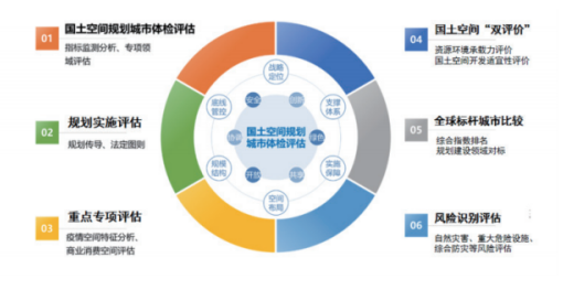
The system constructs and quantitatively analyzes urban health assessment indicator systems to timely diagnose problems and shortcomings in territorial spatial governance and urban planning and construction, promote dynamic adjustment and improvement of planning, enhance the modernization level of territorial spatial governance capabilities, and achieve high-quality urban development.
Construction Content:
1. Dynamic Indicator System Construction
Through digital management of urban health assessment indicator systems, constructing an urban health indicator system that balances "scientific and characteristic" aspects, supporting personalized expansion, flexible adjustment, and dynamic maintenance of indicators and indicator systems.

2. Results Reporting and Management
Supporting online submission of urban health assessment results, verifying and controlling indicator data submitted by subordinates to ensure the authenticity and accuracy of assessment results, and conducting multi-dimensional analysis and routine supervision to provide decision-making basis for planning management, dynamic maintenance, and performance evaluation.

3. Application of Urban Health Assessment Results
According to urban health standards and specifications, constructing urban health indicators and analysis models to achieve quantitative spatial analysis of urban health indicators in spatial patterns and functional layouts, efficiently diagnosing urban current conditions, identifying problems and shortcomings, automatically generating health reports, and providing decision-making basis for urban development.

Application Cases:
Shenzhen Territorial Spatial Planning Urban Health Assessment System
Facing the needs of Shenzhen's territorial spatial planning full life cycle management, constructing a technical architecture for territorial spatial planning urban health assessment, using thematic databases as the foundation, and the smart planning information platform as the technical platform to support the operation of the territorial spatial planning urban health assessment system and realization of various application scenarios. Meanwhile, formulating various standards and specifications, constructing a supporting guarantee system, and jointly promoting the completion of health assessment tasks to meet the business needs of various planning management and planning research departments.
Related Software
NRSMA
NRSDMS
- Natural Resource Asset Management Solution
- Intelligent Disaster Management Solution
- Solution for Urban Physical Examination Evaluation Information
- Implementation Supervision Information Solution for the "One Map" of National Spatial Planning
- Solution for Land Space Use Control and Supervision
- Green Mining Intelligent Solution


