


NRSMA
In response to the new positioning and new demands of the surveying and mapping geographic information industry in serving economic and social development and ecological civilization construction in the new era, and based on the construction concept of real 3D China, Zhongdi Digital has built a set of "one database, one platform, N applications" real 3D business system based on the independently controllable MapGIS 10.6 full space intelligent GIS platform.
Based on domestic software and hardware infrastructure, integrating and aggregating geographic scenes, geographic entities, geographic units, and IoT sensing data to form a real 3D database, constructing a real 3D data management system, a real 3D operation and maintenance management system, and a real 3D application service system. It provides progressive 3D scene services from efficient management of real 3D data, visual browsing, IoT sensing, application upgrades to simulation and deduction, creating a domestic spatiotemporal digital foundation for Digital China construction, supporting application scenarios such as government governance, natural resources industry management, and public services.
Solution Highlights

Functional Modules
1. Multi-source Real 3D Data Integration and Management
Addressing the pain point of difficult data aggregation, it supports integrated aggregation and fusion of multi-source data including oblique photography, remote sensing images, DEM, BIM, 3D models, laser point clouds, geological bodies, vectors, and real-time IoT sensing data. Through a series of tools such as projection transformation, data registration, data quality inspection, data fusion, and cache generation, data is standardized and spatiotemporal processed. Using distributed databases, dynamic allocation of data storage strategies for different data is implemented to achieve unified integrated management of multi-source data including geographic scenes, geographic entities, 3D models, and IoT sensing.

2. "One Code, Multiple States" Entity Construction and Graph Association
Addressing the multi-modal and multi-temporal characteristics of geographic entities, it provides entity processing tools such as batch import of graphic elements, entity data conversion, entity coding, and graphic element attribute editing to support rapid construction of geographic entities. Based on this, it supports the construction of relationships between entity graphic elements, spatial and semantic relationships between entities, and relationships with non-entity data. Using knowledge graph technology, it provides query statistics and knowledge graph services based on geographic entities, transforming "human understanding" into "human-machine compatible understanding".

3. Rapid Visualization of Ultra-large Scene Real 3D
Addressing the pain point of slow display and loading of real 3D data, through optimized scheduling strategies such as node merging, node relationship reconstruction, and streaming texture compression, it constructs multi-level, multi-layer M3D2.0 cache, supporting online loading of ultra-large scale, full-space geographic scene and geographic entity data, and providing services such as 3D scene management and scene roaming, achieving high-fidelity and efficient visualization rendering of large scene real 3D data.
4. Powerful and Rich Real 3D Spatial Analysis
Addressing the challenge of weak real 3D application support, it extends 3D spatial analysis from above ground to underground, providing full-space integrated analysis capabilities, including line-of-sight analysis, viewshed analysis, openness analysis, skyline analysis, sunlight analysis, profile analysis, model flattening, height control analysis, terrain analysis, surface excavation, geological analysis, full-space clipping, and full-space analysis for land application approval, supporting online real 3D stereoscopic decision-making and judgment, empowering diverse real 3D business applications.

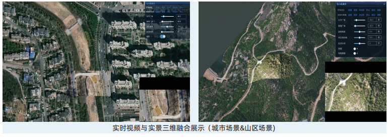
5. Real-time Video Overlay Display Integrated with Real Scenes
To ensure the real-time nature of the real 3D digital space in terms of time, by constructing a unified IoT sensing management middleware, it supports access to various real-time videos from drones, fixed cameras, etc., achieving real-time fusion and overlay display of video and real 3D scenes. It can be applied to both urban and mountainous scenarios, achieving zero-delay and precise projection, making real 3D "come to life". In addition, it also provides historical video management and playback, supporting historical scene reproduction, serving scenarios such as emergency monitoring, law enforcement supervision, and road patrol.
6. Efficient and Stable Real 3D Operation and Maintenance Management
Adopting microservices and distributed cluster management architecture, seamlessly integrating the Spark distributed computing framework, directly connecting to the full-space 3D model data service interface specification M3D, providing functions such as resource catalog management, service resource management, resource monitoring, cluster management, log management, and user permission management, supporting efficient operation and maintenance and multi-level permission management of real 3D data resources, service resources, and application resources, achieving unified supervision, efficient scheduling, and security auditing of various real 3D resources.

Application Cases:
National New Fundamental Surveying and Mapping System Construction Shandong Pilot Project (UAV Video Fusion)
Based on real 3D geographic scenes, researching the technology of integrating UAV real-time video with geographic scenes, providing full-process management from device access, video shooting to scene overlay display, achieving zero-delay and precise projection display of real-time monitoring video in real 3D scenes, making real 3D "come to life", helping emergency command, law enforcement supervision, road patrol and other scenarios transform towards remote, intelligent, visual, and "Internet + supervision" methods.
Related Software
NRSMA
NRSDMS
- Natural Resource Asset Management Solution
- Intelligent Disaster Management Solution
- Solution for Urban Physical Examination Evaluation Information
- Implementation Supervision Information Solution for the "One Map" of National Spatial Planning
- Solution for Land Space Use Control and Supervision
- Green Mining Intelligent Solution


