Zhongdi Digital CSPON Solution: Building a New Paradigm for Intelligent Governance of National Land Space
Against the backdrop of rapid urbanization, urban populations have surged, and the contradiction between people and land has become increasingly acute. Territorial spatial planning is the core means of rationally allocating resources, protecting the ecology, and promoting orderly urban development. The implementation of planning cannot be separated from precise monitoring; otherwise, it easily leads to resource waste, ecological damage, and disorderly urban expansion, constraining sustainable urban development. At this critical juncture, Zedigital has launched the MapGIS Territorial Spatial Planning Implementation Monitoring Network (CSPON) solution, bringing new ideas and methods to territorial spatial planning implementation monitoring with advanced technology and innovative concepts, helping to address many current challenges.
Buildinga Full-chain Intelligent Monitoring System
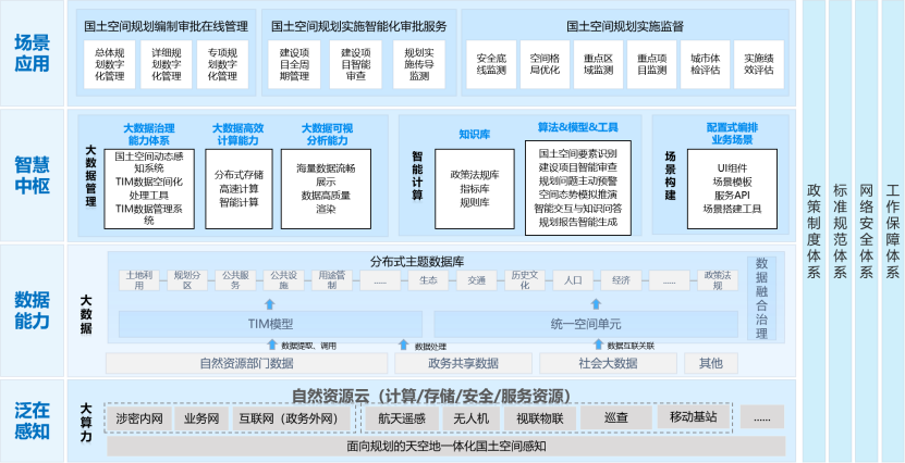
CSPON takes "horizontal connectivity and vertical integration" as its construction goal, building a systematic solution through nine core tasks, covering key areas such as system construction, data governance, model development, and ecosystem construction. Relying on the "One Map" Implementation Supervision Information System for Territorial Spatial Planning, it expands capabilities such as dynamic perception, real-time monitoring, and automatic early warning, achieving full-process online implementation of planning compilation, approval, implementation, and supervision. By overlaying high-precision three-dimensional data calculations and professional planning models, it enhances the scientific nature of decision support. It establishes a multi-source data fusion mechanism, integrating natural resources data, government-shared data, and social big data, forming a "data acquisition-governance-application" closed loop.
The solution is based on the Territorial Information Model (TIM), connecting spatial entity data with business models to achieve flexible agile collaborative governance. It introduces AI large models and intelligent algorithms to build a professional model library for territorial spatial planning covering scenarios such as element recognition, conflict analysis, and simulation deduction. Meanwhile, through full-information innovation adaptation, it ensures system security and reliability, meeting national autonomous and controllable strategic requirements.
Full Business Chain Intelligent Application Practice
CSPON focuses on the pain points of territorial spatial governance, building six categories of 35 rule libraries and 140+ intelligent operators, forming a "data-driven-model calculation-scenario implementation" closed loop, achieving dual improvements in governance efficiency and accuracy.
Online Management of Planning Compilation and Approval: Full-process Collaboration
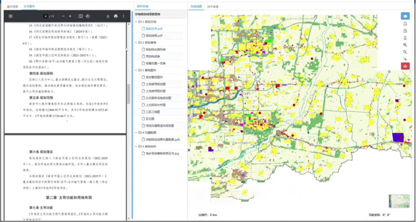
Through online consultation and data classification and grading sharing mechanisms, it digitizes the entire process of planning demand collection, compilation plan coordination, and outcome submission, eliminating data silos and repetitive work. It introduces automated quality inspection tools to conduct compliance verification of planning outcomes, supporting dynamic adjustment and version management of planning to ensure the accuracy and timeliness of planning transmission.
Intelligent Approval Services: Penetrative Compliance Review
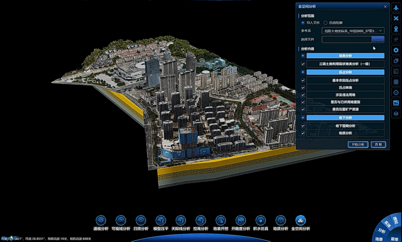
It builds six categories of rule libraries including spatial access, planning compliance, and indicator restrictions. Combined with map-based approval and three-dimensional spatial analysis, it achieves "penetrative" review of construction projects, automatically deducts indicators and updates business data in real-time. Relying on the three-dimensional "One Map" of natural resources, it integrates multi-source data such as the three surveys, three zones and three lines, and cadastral ownership to provide integrated graphic and text approval methods, improving the accuracy of land use and mineral approval.
Implementation Supervision and Monitoring: Bottom-line Control and Dynamic Assessment
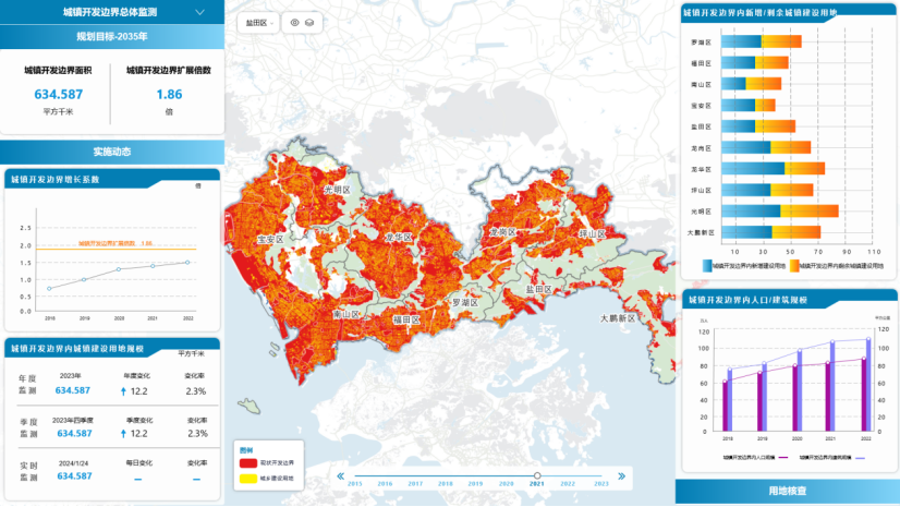
Taking the three zones and three lines as the core, it dynamically monitors indicators such as urban development boundaries, cultivated land protection, and ecological red lines. Through remote sensing AI recognition and model calculations, it automatically generates monitoring reports and warns of violation risks. It builds an indicator system covering eight categories including natural resources, socio-economic, and people's livelihood services, achieving multi-level physical sign monitoring and early warning at city, district, and street levels, providing decision-making basis for high-quality urban development. Using means such as UAV aerial photography and video surveillance, it conducts full life cycle supervision of major projects, real-time tracking of approval progress, construction processes, and implementation effects, preventing issues such as approved but unused land and unauthorized over-construction.
AI Large Model Driven Governance Upgrade
CSPON takes generative artificial intelligence as its core, building an innovative application ecosystem of "intelligent perception-interactive decision-making-automatic generation," promoting the transformation of territorial spatial governance from "passive response" to "active intelligence."
Planning Knowledge Base and Multi-source Data Governance
It builds a professional knowledge base for territorial spatial planning, integrating structured data resources such as policies and regulations, technical standards, and excellent cases. Through knowledge graph construction and dynamic update mechanisms, it achieves intelligent interpretation and semantic association of multi-modal data, providing real-time policy interpretation, standard query, and case reference services for business personnel, supporting scientific decision-making of planning schemes.
Dynamic Indicator Monitoring and Intelligent Recognition
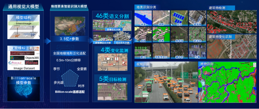
Based on visual large models, it builds a remote sensing image interpretation system, achieving automated monitoring of 17 categories of physical examination and evaluation indicators. Through functional modules such as building change recognition and land use nature detection, combined with thermal infrared image time series analysis technology, it automatically generates indicator early warning information. The system can automatically identify the spatial relationship between new buildings and planning red lines, and push early warning information to the decision-making end in real-time.
Intelligent Q&A and Report Generation
It develops a planning intelligent assistant, integrating NLP engines and professional corpora, supporting natural language interactive indicator queries and report generation. When relevant instructions are input, the system automatically associates the indicator database, and through the content generation and logical reasoning capabilities of large models, outputs professional reports including data visualization, problem diagnosis, and optimization suggestions.
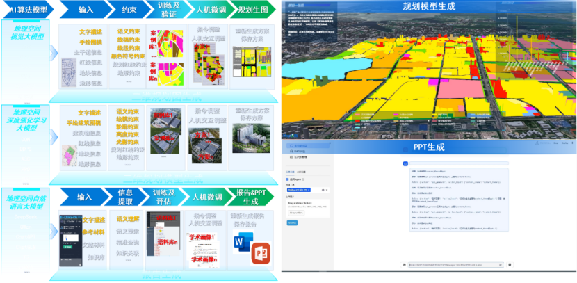
Zedigital's CSPON solution is guided by technical professionalism and scenario practicality, providing full-cycle, intelligent support for territorial spatial planning implementation through a governance model of "data integration, intelligent drive, and scenario implementation." In the future, with the deep integration of AI large models and spatiotemporal technology, CSPON will continue to enhance governance efficiency, helping to build a more intensive, efficient, intelligent, and secure new pattern of territorial spatial development.


