MapGIS provides insight into underground resources, empowering precise mineral exploration
Mountains stand silently, drilling rigs roar, and the sound of geological hammers striking rock layers contains precious mineral resources. With the deep advancement of the new round of strategic action for mineral exploration breakthroughs, how to crack the earth's code and accurately explore underground resources has become a key issue in ensuring national resource security.
Mineral resources, as the "grain" of industrial development, directly relate to the nation's strategic resource reserves in terms of exploration accuracy. Under the policy guidance of the Ministry of Natural Resources, the newly revised "Mineral Resources Law" of 2023 first clarified the mineral resource reserve system in legal form, and new specifications such as "Solid Mineral Resource Reserve Estimation Procedures" have put forward higher requirements for digital exploration technology.
Zondy Digital deeply responds to policy guidance, leveraging over thirty years of geological informatization experience to launch the MapGIS Mine Management and Modeling System. Based on the MapGIS platform, this product is designed for solid mineral resource exploration, integrating field survey data management, geological mapping, ore body delineation, deposit geological modeling, and resource estimation throughout the entire process. It achieves digitalization and visualization of the entire solid mineral exploration process, providing deep empowerment for solid mineral exploration and mine management work.
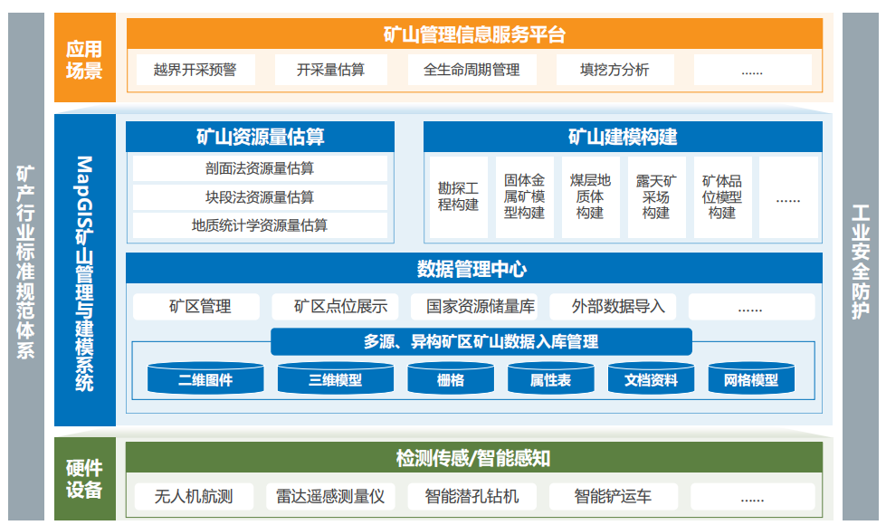
01 Integrated Management of Multi-source Heterogeneous Data
Supports the storage and management of various mining area attributes and spatial data, achieving integrated storage and management of multi-source heterogeneous, multi-scale, multi-dimensional dynamic mineral exploration comprehensive data. Strictly following the "Mineral Resources Reserve Database Standard" and "Solid Mineral 3D Modeling Database Standard", it organizes data entities through a three-level architecture of mining area-mine-annual, ensuring zero-exchange inheritance throughout the process. The data management mechanism maintains compatibility with the original Ministry of Land and Resources' mineral resources reserve database management system, meeting the horizontal interconnection requirements for scenarios such as reserve review and mining right registration.
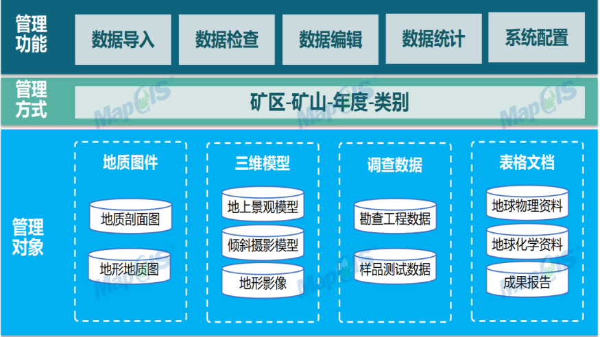
02 Geological Modeling and Accurate 3D Scene Reconstruction
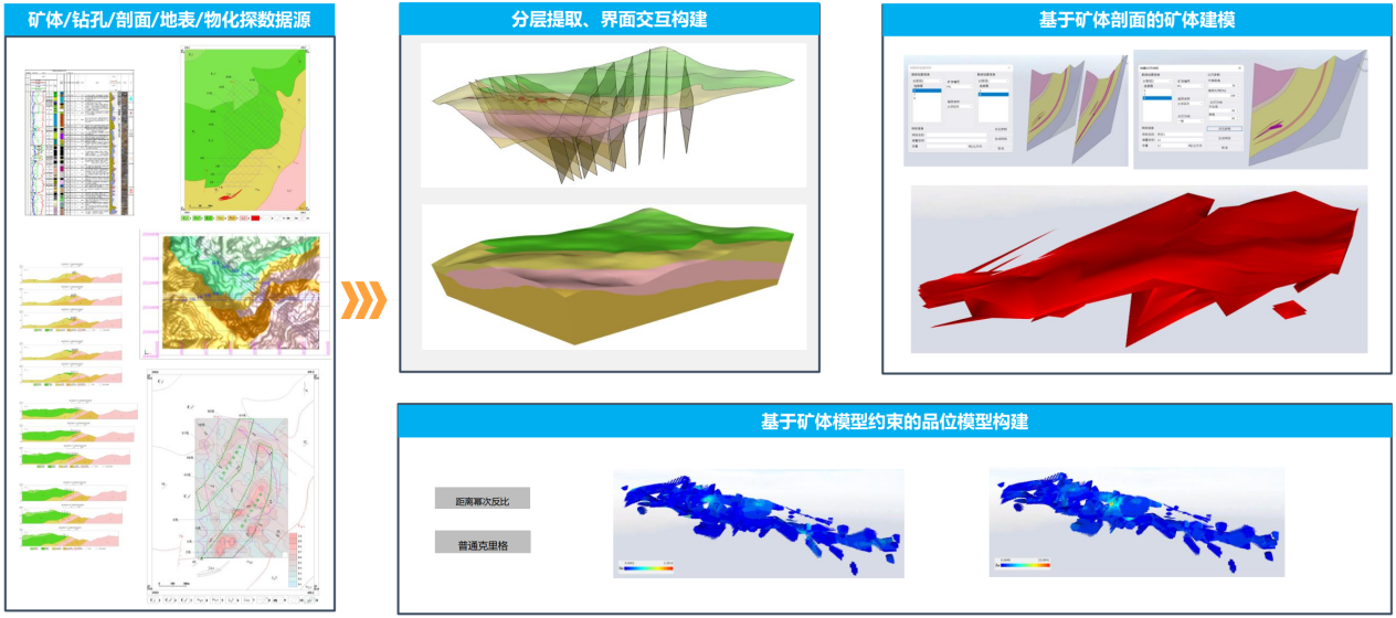
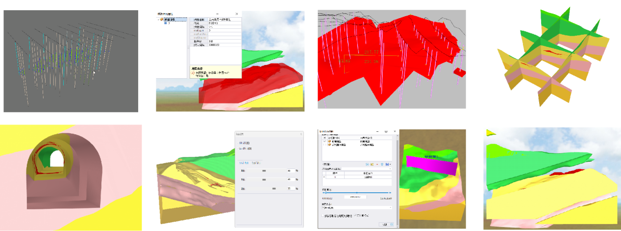
The system integrates multi-source heterogeneous mineral exploration data including surface topography, exploration profiles, borehole data, and tunnel engineering, rapidly constructing exploration projects, ore bodies, and rock mass models to intuitively present three-dimensional scenes and achieve integrated model construction throughout the process. Supports attribute queries of stratigraphic models, model explosions, tunnel cutting, and various morphological cutting display analysis operations, helping users understand the internal and external forms of models and stratigraphic construction, providing scientific basis and auxiliary decision-making for mine excavation and mine supervision.
Supports various modeling methods for open-pit and underground mining, accurately reconstructing mine geological structures to provide scientific basis for mining planning, assisting in efficient and safe advancement of mine projects, and meeting modeling needs in different scenarios.
03 Authoritative Certified Resource Estimation Algorithms
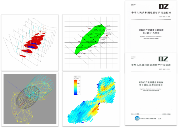
Built-in industry-standard cross-section method (section method), block method, geostatistics method (distance power method and ordinary Kriging) - 4 resource estimation methods. The system has successfully passed the review by the China Association of Mineral Resources Appraisers, verified through multiple actual projects, with less than 1% deviation compared to real exploration data reports, ensuring accurate estimation results.
04 Intelligent Output of Full-process Results
Deeply integrates geological exploration business processes, with built-in 20+ industry-standard map templates and report templates, supporting batch one-click output of results such as histograms, cross-section diagrams, and resource estimation tables, greatly improving the efficiency of resource estimation report preparation and significantly releasing geological engineers' productivity.
With the deep advancement of the new round of mineral exploration strategic action, Zondy Digital will continue to optimize 3D geological modeling technology, strengthen algorithm innovation and intelligent applications in the field of mineral exploration, and provide solid support for national mineral resource security with advanced digital technology.


