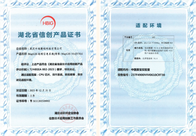
Independently controllable, Zhongdi Digital has obtained the first batch of evaluation and certification for innovative information technology application products in Hubei Province
Recently, the first batch of evaluation and certification results for Hubei Province's information technology application innovation products, organized by the Hubei Software Enterprise Association and the Information Technology Application Innovation Working Committee, were announced. The independently controllable platform product "MapGIS Geographic Information System [referred to as MapGIS 10.6] V10.6" of Zhongdi Digital has obtained the evaluation and certification for information technology innovation products.

In order to implement the national deployment of information technology application innovation and provide support for expanding the information and innovation market of software products in Hubei Province, in accordance with the "Evaluation Standards for Information Technology Application Innovation Products in Hubei Province" (T/HBSEA 002-2023), in October 2023, the Hubei Software Enterprise Association and the Information Technology Application Innovation Working Committee, under the guidance of relevant departments, carried out the first batch of evaluation and certification work for information technology application innovation products in Hubei Province.
MapGIS 10.6 is a new generation full space intelligent GIS platform developed by Zhongdi Digital. It integrates advanced technologies such as cloud computing, big data, the Internet of Things, blockchain, and artificial intelligence to achieve the storage, management, analysis, and application of large-scale geographic data, providing users with continuous, robust, and efficient GIS technology support. MapGIS 10.6 comprehensively enhances the five technical systems of cross platform GIS, full space GIS, big data GIS, intelligent GIS, and agile development, and is widely used in industries such as natural resources, geology, municipal administration, public security, water conservancy, and smart cities. It empowers national information strategies such as real 3D China, digital twin cities, urban information model basic platforms, and digital twin watersheds, and promotes high-quality development of the geographic information industry.
As a leading provider of cloud GIS software platforms and solutions in China, Zhongdi Digital has always been committed to developing domestically produced GIS software that is independent, controllable, and internationally competitive. In recent years, MapGIS has undergone multi-level adaptation and integration of information technology chips, servers, databases, cloud platforms, operating systems, etc., creating a full stack spatial information solution in the information technology environment, providing product users and partners with a safe and reliable domestic operating environment. Zhongdi Digital will follow the development trend of the information and innovation era, actively respond to policy guidance, work together with upstream and downstream enterprises in the industrial chain, continuously improve the information and innovation GIS ecosystem, provide a safe and reliable technical foundation for the digital transformation of various industries, and build the cornerstone of the national informationization strategy.


