Backend development of diversified components and cloud GIS service development capabilities to safeguard geospatial security
According to the Ministry of National Security, recent work by national security agencies has found that overseas geographic information system software used in important industries in China is collecting and disseminating geographic information data. Some of the data is sensitive and even involves state secrets, posing a serious threat to China's national security. In response to the above situation, national security agencies, together with relevant departments, will carry out a special investigation and governance of geographic information data security risks, guide and assist relevant units in carrying out inspections and rectification, and timely eliminate major security risks such as data theft and leakage.
This once again tells us that the localization replacement of GIS software is urgent! With the continuous deepening of the development of Xinchuang GIS, the current Xinchuang replacement has gradually evolved from initial ecological adaptation to application layer replacement. In order to meet the needs of current application replacement and ensure the autonomy, security, and reliability of applications, the MapGIS 10.6 Pro backend development focuses on enhancing the component development platform and MapGIS Boot microservice backend development framework in the Xinchuang environment, providing diversified component and cloud GIS service extension development support capabilities.
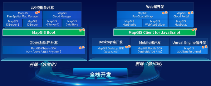
MapGIS 10.6 Pro Full Stack Development System
Enhance component development capabilities in the information and innovation environment
The MapGIS component development framework is based on a unified cross platform kernel, providing MapGIS Objects SDK and MapGIS Desktop SDK, including 4 categories of 20+core component resources, 5 categories of core control resources, 6 categories of plugin development resources, and 20+functional plugin resources. MapGIS 10.6 Pro further enhances the component development capabilities in the information and innovation environment. The MapGIS Objects SDK (Java) provides a fully functional development interface, adds a solid model storage management component, and enhances spatial data management and 3D analysis components. MapGIS Objects SDK(Python)& Toolbox, providing lightweight script building capabilities and supporting ready to use, lightweight and fast development methods; The MapGIS Desktop SDK supports drag and drop visualization for building desktop GIS applications, where what you see is what you get.
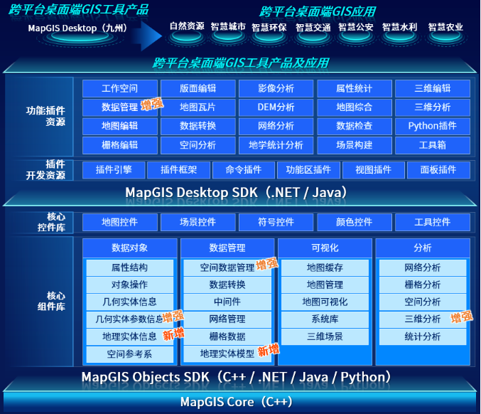
MapGIS Component Development Framework
The MapGIS component development platform is embedded with Python IDE and runtime environment, supporting the extension of development tools through Python language, making it easy for users to flexibly customize tools that meet business needs to meet more application scenarios. Extended Python tools can run independently or be used in conjunction with other tools in the toolbox.
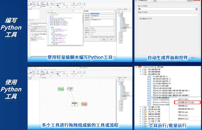
Component development extension based on Python
The MapGIS desktop development platform is based on the highly scalable development framework MapGIS Desktop SDK, providing a "framework+plugin" development mode with rich plugin resources built-in. It supports asynchronous development, rapid aggregation, and reconstruction of GIS applications, and allows for drag and drop visualization to quickly build desktop GIS applications.
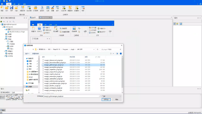
Drag and drop visualization for building desktop GIS applications
Upgrade of Cloud GIS Service Development Capability
Based on the GIS core capabilities provided by the component layer, MapGIS has built a microservice backend development framework called MapGIS Boot. MapGIS Boot is a cloud native development framework developed based on the Spring Boot and Spring Cloud technology stack, providing various deployment packages such as Docker Compose and K8s, supporting both monolithic and microservices deployment. The product comes pre installed with rich microservice resources, such as microservice gateway, permission authentication, task management, system management, monitoring management, etc. Support microservice expansion and monolithic service expansion modes, meeting the comprehensive technical development capabilities of fast, flexible expansion, seamless integration, and high-performance services for mid to back-end application development.
MapGIS 10.6 Pro upgrades MapGIS Boot based on open-source technology stack and information technology stack. In order to better meet the needs of information and innovation, and gradually achieve the localization replacement of open source technology, MapGIS Boot is fully adapted to the information and innovation ecosystem, supporting domestic chips such as Kunpeng and Feiteng, as well as domestic operating systems such as Kirin; Data storage supports Renmin Jincang DM、 Domestic databases such as Yashan; Middleware supports domestic middleware such as Kingdee and Dongfangtong, laying the foundation for backend development in the business system innovation environment.
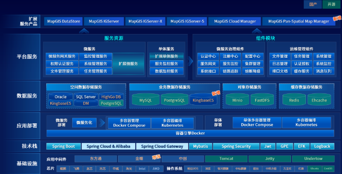
MapGIS Boot microservice backend development framework
Based on MapGIS Boot, three backend cloud GIS service development modes are provided, including independent cloud service development extension, IGServer service extension, and geographic processing flow engine service development extension.
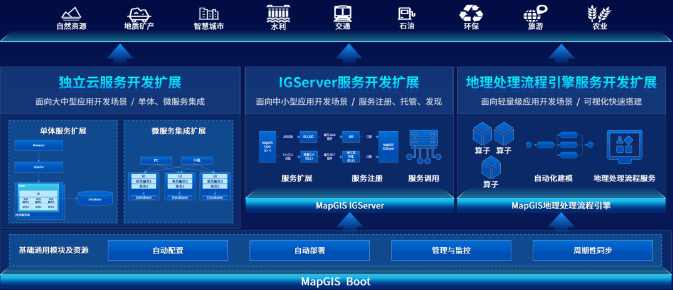
Development and Extension Model of Cloud GIS Services Based on MapGIS Boot
The development and expansion of independent cloud services is based on the rich microservice resources provided by MapGIS Boot, and independently builds server products that support monolithic and microservice integration. It is mainly aimed at the development and integration of large and medium-sized applications.

Development of independent cloud service extension based on MapGIS Boot
The development and extension of IGServer services mainly rely on the service "extension registration call" mechanism of MapGIS IGServer, hosted on IGServer, and mainly targeted at small and medium-sized application development scenarios.
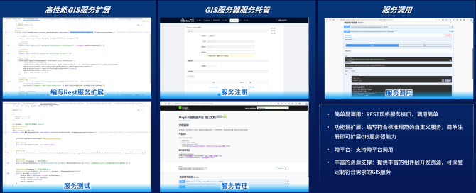
Development of Service Expansion Based on MapGIS IGServer
The development extension of geographic processing flow engine service is based on MapGIS geographic processing flow engine, which visualizes and automatically models based on operators, and then releases geographic processing flow services, mainly targeting lightweight application development scenarios.
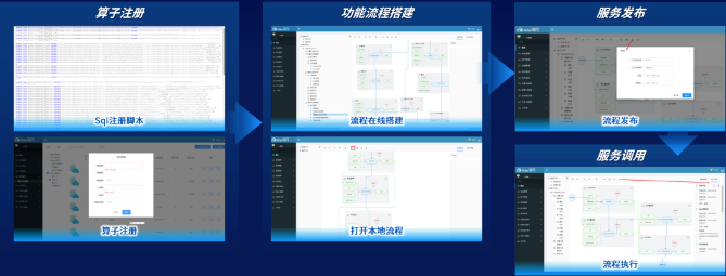
Development of Service Expansion Based on Geographic Processing Flow Engine
MapGIS 10.6 Pro provides rich backend service development resources, including development guides, development APIs, etc., which can help developers quickly get started; In addition, the MapGIS Boot product source code is open source and has been hosted on the Github/Gitee open source community. We will continue to iterate and upgrade to provide comprehensive support for development users.
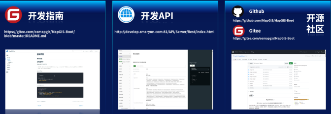
MapGIS backend service development resources
Geographic information data belongs to high-value intelligence and is a key focus of intelligence theft by overseas spy agencies. By stealing high-precision geographic information data from our country, we can restore three-dimensional topographic maps of specific areas in important fields such as transportation, energy, and military, providing critical support for reconnaissance, surveillance, and military operations, which will seriously threaten national security. At present, MapGIS 10.6 Pro full stack development products have been widely used in industries such as real-world 3D, CIM platform, digital twin, natural resources, smart cities, smart geology, smart agriculture, water conservancy, transportation, and petroleum, fully empowering the research and development of innovative applications in spatial information digital economy, and providing a safe and reliable technical foundation for digital transformation in various industries.


