MapGIS CIM Cloud Portal is a comprehensive GIS cloud service portal that enables the integration, rapid search, diversified display, collaborative sharing, and comprehensive management of GIS resources such as data, services, applications, maps, large screens, and typical applications. Capable of zero code customization, able to quickly customize exclusive CIM portals.

1、 Autonomous and controllable basic software and hardware environment support
●Supports mainstream CPU architectures and domestic chip platforms, including X86, ARM, MIPS, Alpha, LoongArch64, as well as domestic chips such as Feiteng, Kunpeng, Loongson, Shenwei, Zhaoxin, and Haiguang
●Supports commonly used Linux operating systems both domestically and internationally, such as RedHat, CentOS, Ubuntu, UOS, Zhongbiao Kirin, Galaxy Kirin, Deeptech, Euler, Zhongke Fangde, Wanli Hong, Hongqi, as well as Windows systems
●Support multiple domestic and international cloud platforms such as Huawei and Kubernetes

2、GIS resource integration capability
●Integrate data, services, applications, maps, large screens, typical applications, and other resources to achieve unified management of multiple resources
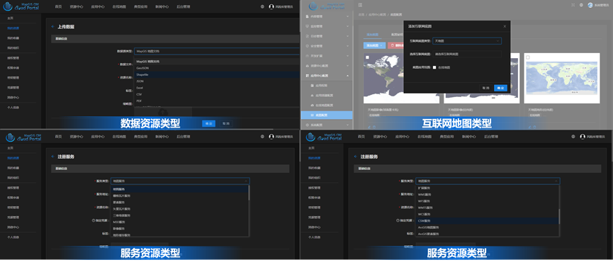
●Support registration of MapGIS REST, OGC REST, heterogeneous GIS platform REST services, 3DTiles services, M3D services, terrain caching services, and other REST services, as well as other service types
●Support access to Internet maps such as Skymap, Baidu Maps, Google Maps, OpenStreetMap, etc
●Support uploading Excel、CSV、Mapx、HDF、HDB、MBTiles、TPK、GeoJSON、MUVT、VTDF、MSI、TIFF Common data types, as well as other data types
3、GIS Resource retrieval capability
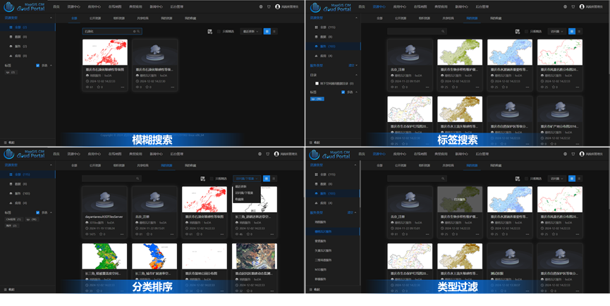
●Support multiple methods such as fuzzy search, type filtering, tag filtering, directory filtering, and classification sorting to quickly locate resources such as services, data, applications, maps, large screens, and typical cases
●Support custom configuration of resource display directories such as data, services, applications, maps, and large screens according to business needs. Administrators can manually create resource directories or automatically build resource directories by combining resource metadata templates
4、GIS resource sharing and collaboration capability
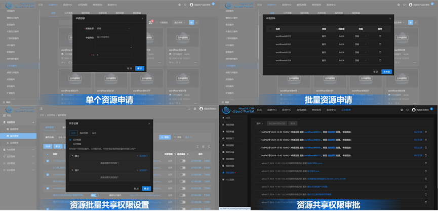
●Supports multiple service sharing methods, such as public, private, and specified scope, to achieve collaborative sharing between multiple organizations
●Support for online application and approval of resource access permissions, allowing resource owners, department administrators and system administrators to approve authorization applications online
●Supports cluster management of GIS resources, allowing resource isolation between different organizations according to the organization style
●Supports system administrators to manage all resources in the portal system, department administrators can manage all resources in the department
●Supports single function level role authorization mechanism to realize multi-level management of portal function resources
5、GIS Resource management capability
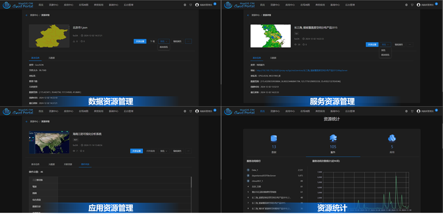
●Support uploading and registering various data resources, provide preview, overlay preview, service publishing, view/edit details, set sharing permissions, review, delete and other management operations
●Support multiple service registration mechanisms such as single service registration, Excel batch service registration, server addition, etc. Provide service preview, overlay preview, view/edit details, settings, share permissions, review, delete and other service resource management operations
●Support application building, providing management operations such as creating, opening, previewing, viewing/editing details, setting sharing permissions, auditing, deleting, importing/exporting, etc
●Support online mapping application management, providing management operations such as creating, opening, previewing, viewing/editing details, setting sharing permissions, reviewing, deleting, etc
●Supports typical app release and management, providing app release, view/edit details, delete, audit, etc.
●Supports online news hotspots, providing publishing, viewing/editing details, deleting, auditing, etc.
●Support diversified resource statistics and visual display, providing indicators such as overall resource situation statistics, resource traffic, selected resources, popular resources, ranking statistics, etc., to facilitate managers to better grasp the resource situation and manage the portal well
6、Online map visualization and analysis capabilities
●docking portal service resource directory, support portal service online overlay preview
●Supports overlay preview of data, services and other resources that are dynamically selected by users
●Support access to portal resources, URL resources, realize multi-source GIS service resources online overlay preview
●Support loading vector data, raster tiles, vector tiles, terrain, images, oblique photography, point clouds BIM、 Multi source heterogeneous spatial data such as fine models, architectural white models, and grid voxels
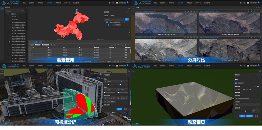
●Support integrated 2D and 3D query and statistics, providing interactive spatial query functions such as clicks, rectangles, polygons, polylines, administrative divisions, as well as custom queries, model picking, and other functions
●Provide query result set management, support pagination display, graph linkage, result annotation, positioning, highlighting, popup details and other functions, support exporting query results
●Supports measurement functions, including two-dimensional universal measurement functions such as length, area measurement, as well as plane, field, glue, triangulation and other types of measurement in 3D scenes
●Provides general topography analysis functions such as high lines (faces), slopes, slopes, flooding, digging sides
●Provides visibility analysis such as overview, field of view, shadow, profile, skyline, etc.
●Provide model analysis such as model stretching, dynamic cutting
●Supports adjusting shadow effects, display frame rate, compass controls, zoom controls, status bar, brightness, compass, timeline, atmosphere, depth detection and other scene parameters
●Supports scene roaming control, providing advanced features such as mouse control mode, collision detection, moving steps, panoramic roaming, non-panoramic roaming, stop roaming
●Provides 3D scene roaming, supports interactive drawing paths, import local paths, export paths, etc.
●Provides 3D effects such as camera, lighting, weather, scene floodlights, rain and snow effects
●Provides split screen, roll curtain and other functions for scene interaction and management
7、Ability to build "One Picture" application
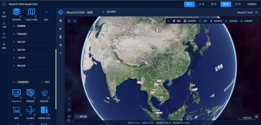
A fully functional industry "one map" application developed based on MapGIS full space one map product to build a WebApp. It has the characteristics of no plugins and good compatibility, and can quickly build industry "one map" applications, realizing integrated management, display, statistics, analysis, simulation and professional application of air, surface, ground and underground full time and space data
●Supports the quick creation of "one chart" industry applications by dragging, what you see is what you get
●Supports online creation, saving, sharing, saving, previewing, creating copies, importing, exporting and other applications to build engineering management operations
●Support the construction of a full space data directory tree to achieve standardized management and unified access of full space data services in a standard directory manner. Support manual creation of resource directories, or registration of data directories generated by automatic cataloging such as cloud portals and cloud management. Provide data directory import and export functions
●Support theme management, preset multiple chart theme resources, support dynamically add user custom themes, can quickly switch themes, adjust styles, configure theme colors
●Supports property management, you can set the system logo, title, subtitle, menu link and other property functions on demand
●Supports widget management, manages a chart to pre-set and dynamically add user custom widgets, and quickly build applications using pre-set and added user custom resources
●Provides 100 basic and industry-specific micropart resources, covering all GIS functions:
1.Support vector, images, tiles, terrain, models, grid elements and other all-time data integration management
2.Supports spatial data and real-time data, IoT, panoramic, chart data, document data and other data entity association management
3.Provides a full spatial view to achieve an integrated display of all spatial data in the air, on the ground, on the surface and underground
4.Provides multi-dimensional views to visualize spatial data, non-spatial data, panoramic data, graphic data, IoT perception data and business data
5.Provide visual contrast, time-space roaming, simulation simulation, scene projection and other functional micropieces to realize four-dimensional time-space simulation and contrast
6.Provide thematic applications and indicator statistics functions, supporting thematic maps such as single value, segmentation, level, and statistics, as well as dynamic and static visualization effects such as heat maps, honeycomb maps, trajectory maps, aggregation annotations, and statistical charts
7.Provide a variety of 3D particle special effects, post-processing special effects to achieve more realistic 3D special effects expression
8.Supports GIS spatial analysis, big data GIS analysis, intelligent GIS analysis and many other server-side analysis
9.Supports topographic analysis, model analysis, visibility analysis, comprehensive analysis and many other client comprehensive analysis
10.Supports a variety of geological analysis and calculation functions such as model cutting, tunnel simulation, virtual drilling, foundation pit excavation, quarrying
11.Supports burst pipe, collision, connection, section, flow direction and many other underground pipeline professional analysis and calculation function
12.Support deep detection, aging equipment detection, isolation point inspection, suspension line inspection and other underground pipeline data inspection, detection function
8、Online mapping capability
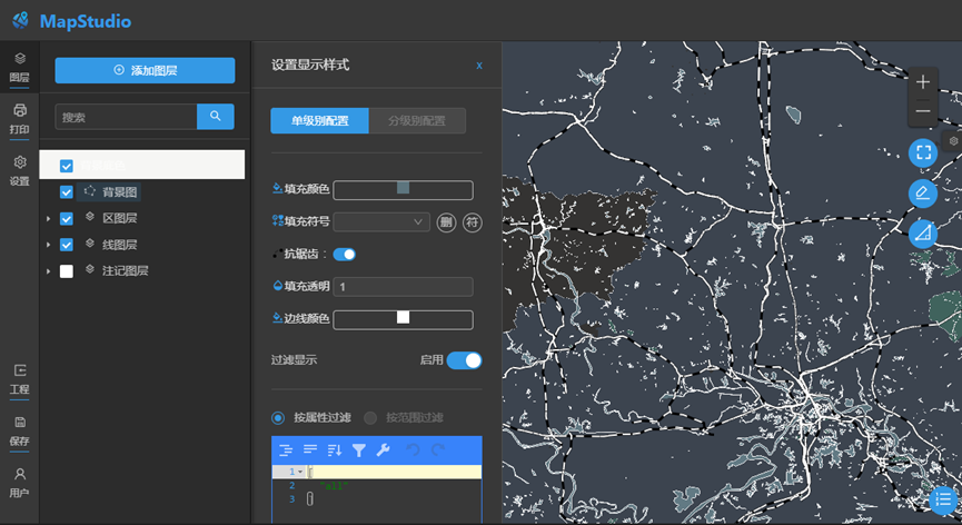
A specialized online mapping tool that provides multiple styles of map templates, ready to use, suitable for different business scenarios, supports rich custom map expressions, and quickly produces exquisite professional maps
●Provides a variety of themed drawing templates, supporting template auto-adaptation, icon customization, dynamic style adjustment, drawing results print output
●Provides rich theme chart effects, giving users more dimensional, more professional expression effects
●Support for quick switching of layout templates and theme customization
●Support for configuring REST, WMTS, WMS services and various domestic and foreign Internet maps as bottom maps
●Supports open, export, save, create, preview and other engineering management operations
9、Portal customization and expansion capabilities
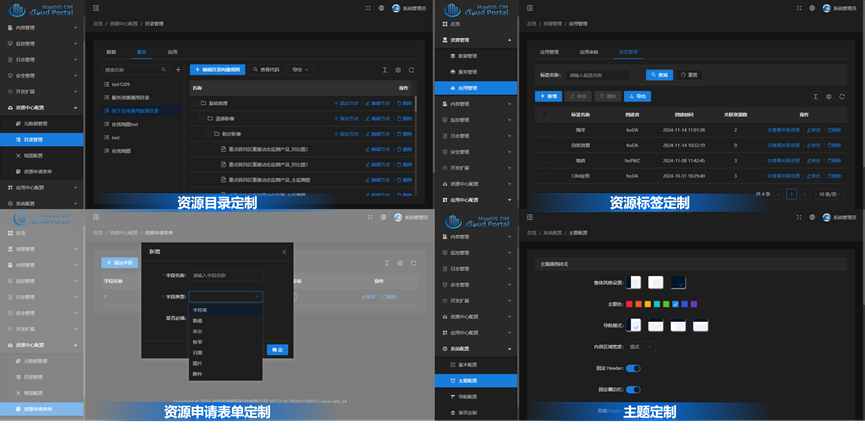
●Built-in multiple light/dark themes, support administrator custom add new themes, one-click change the appearance of the portal
●Support custom page logo, banner icon, title, copyright information and other general content
●Supports custom navigation menus, providing custom navigation menus such as external link applications, internal routing
●Support metadata template customization, users can classify custom data, services, applications and other resources metadata templates
●Supports data dictionary customization, users can build custom data dictionaries by adding, importing, exporting, etc., supports both regular and cascading dictionary modes
●Provides resource directory customization, support for custom configuration or automatic cataloging of data, services, applications and other resource directories based on metadata templates
●Support custom resource tags, users can classify custom data, services, applications and other resource tags
●Support customization of resource application forms, providing various field types such as string, numerical, Boolean, enumeration, date, image, attachment, etc. Users can customize the content of resource application forms as needed by adding form items
●Supports custom resource filters, users can categorize custom data, services, applications and other resources based on the data dictionary in the metadata template
●Supports custom resource filters, users adjust the content and stacking order of resource classification filters as required
10、Resource security management capability
●Supports CAS and LDAP-based integration of existing user account systems, facilitating multi-system integration within the organization
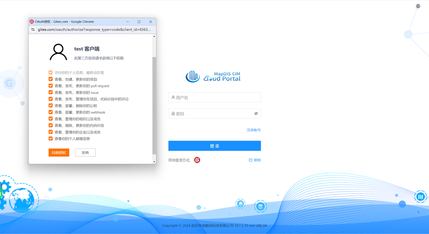
●Support QQ, Weibo, Github, Gitee, custom OAuth2 and other third party logins
Related software
Desktop GIS
BD And Cloud Platforms
MapGIS CIM Basic Platform
Digital Twin Platform


