MapGIS Mobile Explorer is a mobile map browser product that connects MapGIS cloud portal and cloud GIS server map service resources, providing functions such as map browsing, positioning, and measurement. It supports users to access online cloud resources anytime and anywhere, and achieves efficient map production and browsing through simple interactive operations.

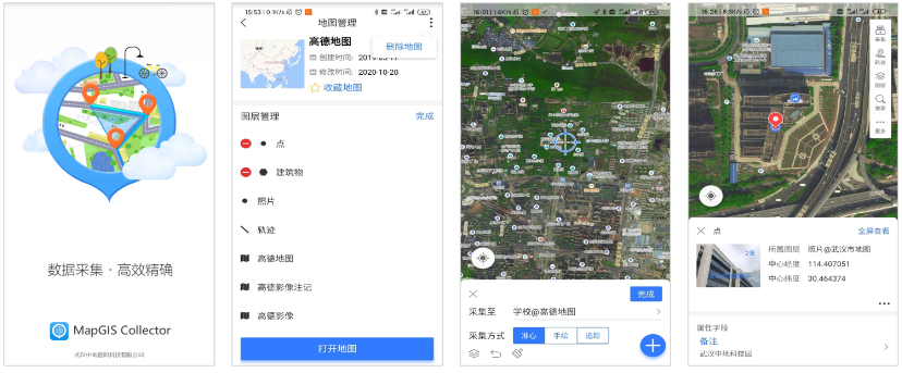
Figure MapGIS Mobile CollectorProduct Function Display
Comprehensive and flexible data management
Comprehensive and flexible data management
● fusionMapGISMap services, open-source map services, and other resources support quick creation of geographic base maps
● Efficient map browsing, supporting offline and online mode access, achieving fast mapping of massive data on mobile devices
● Provide rich layer management functions, supporting operations such as creating and adding layers, sorting layers, and displaying layer information
Powerful data collection function
● Support the collection of multiple data types such as point, line, zone, multimedia, trajectory data, etc
● Provide various geographic information collection modes such as accurate heart, hand drawn, and tracking
● Support one click export function for collected results
● Support user-defined collection layers, personalized display effects, and attribute fields
Intelligent terminal trajectory recording
● Provide trajectory recording function, support intelligent collection of route trajectories, and support trajectory continuation recording, simple and easy to use
● Provide trajectory record file management, support historical trajectory simulation, and achieve perfect presentation of trajectories on the map
Rich collection auxiliary tools
● Provide auxiliary tools such as search, screenshot, thumbnail, bookmark, and cache clearing, which are convenient and practical
● Provide fixed-point photography function, take photos anytime and anywhere, synchronize photos and location annotations on the map, and record scenes instantly
● The measurement tool is flexible and easy to use, providing various operation methods to meet the needs of multi scenario applications
Related software
Desktop GIS
BD And Cloud Platforms
MapGIS CIM Basic Platform
Digital Twin Platform


